
Abstract Automated driving systems (ADS) are being developed faster than any point in history. There is a need to have an independent system to measure the safety of ADS across technologies and corporations. There are a variety of efforts around the world trying to estimate the impact of these systems on safety both prior to and after implementation. A missing piece that could allow for more cohesion and safer implementation is the knowledge of what type of data is needed for the refinement and further development of these systems. The purpose of this project is to determine the best method to … Measuring the Safety of ADS: How safe is safe enough?
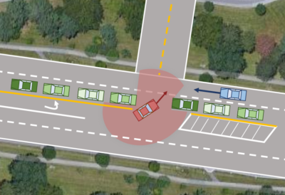
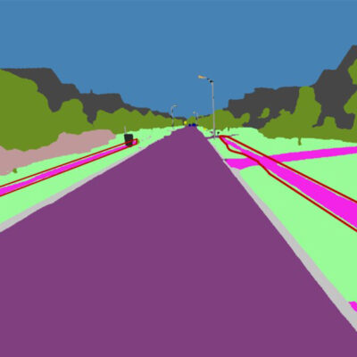
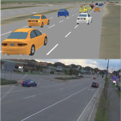
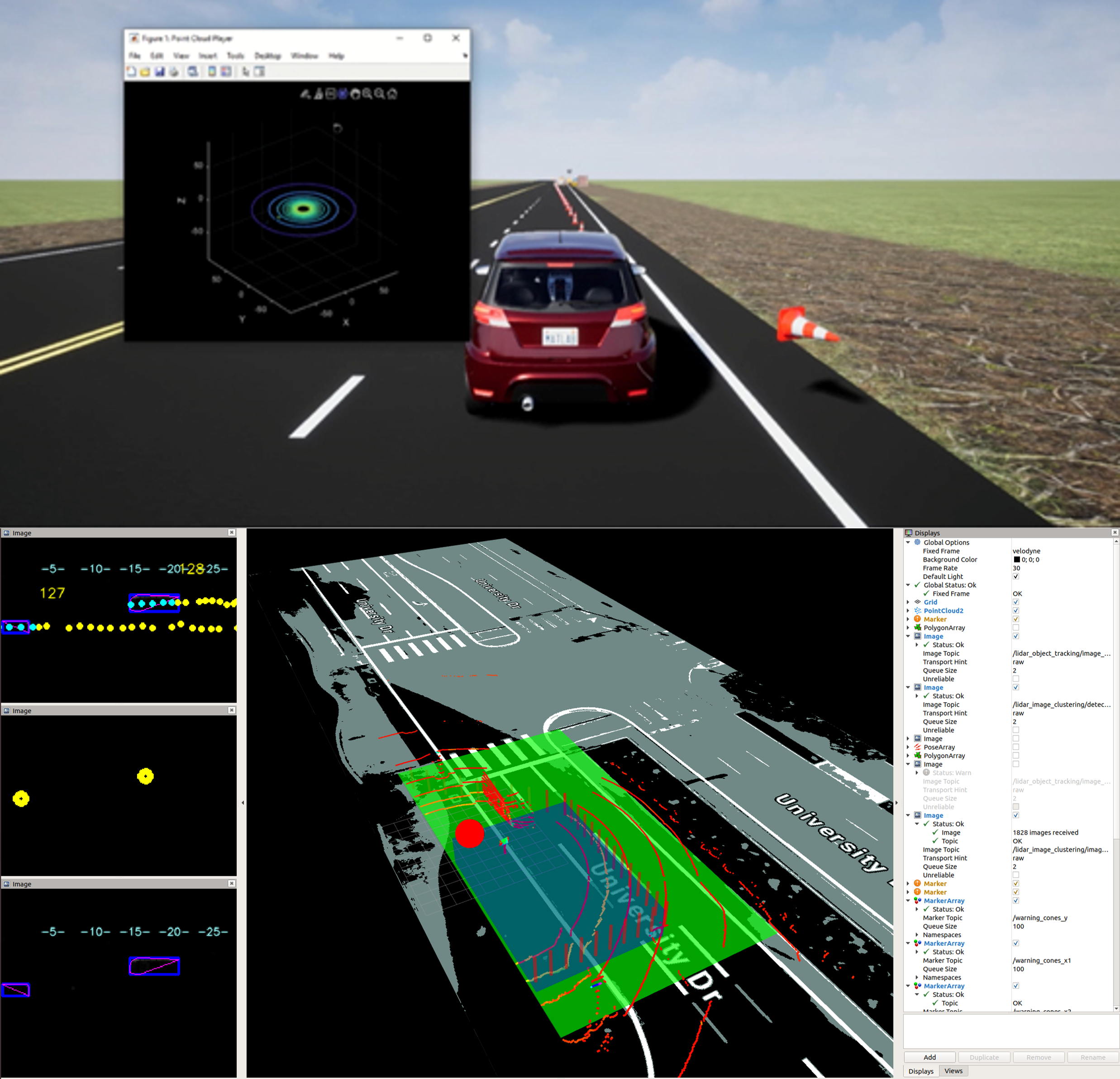
Abstract Intersection-related traffic crashes and fatalities are major concerns for road safety. This project aimed to understand the major causes of conflicts at intersections by studying the intricate interplay between roadway agents. The approach involved using the current traffic camera systems to automatically process traffic video data. As manual annotation of video datasets is a very labor-intensive and costly process, this research leveraged modern computer vision algorithms to automatically process these videos and retrieve kinematic behavior of the traffic actors. Results demonstrated how traffic actors and road segments can be modeled independently via graphs and how they can be integrated … Real Time Risk Prediction at Signalized Intersection Using Graph Neural Network

Abstract Child safety concerns are among the strongest impediments to children walking or biking to school, but some students must walk or bike due to financial or other circumstances. These travel modes are more than twice as common among students from low-income households than students from higher income households. The Safe Routes to School (SRTS) program fosters opportunities for students to walk and bike to school safely and routinely. This study provides insights into the SRTS program’s effectiveness and potential to improve walking and biking safety in socially vulnerable communities by evaluating the program’s impact on schools in the Chula … Evaluating the Safe Routes to School (SR2S) transportation program in socially vulnerable communities in San Diego County, California
Abstract During the last decade, non-motorized modes of transportation, including cycling and walking, have been spreading as they are considered economical, eco-friendly, and energy-efficient. With the expansion of active transportation, statistics show a significant increase in the number of fatalities. Between 2010 and 2019, there was a 36 percent increase in bicycle deaths in the United States. Moreover, despite the 41 percent drop in traffic volume in response to spring lockdowns caused by the Covid-19 pandemic, 697 bicyclists lost their lives in crashes in 2020, and California with 118 fatalities was the deadliest state for bicyclists. In this project, we … Developing a framework for prioritizing bicycle safety improvement projects using crowdsourced and image-based data
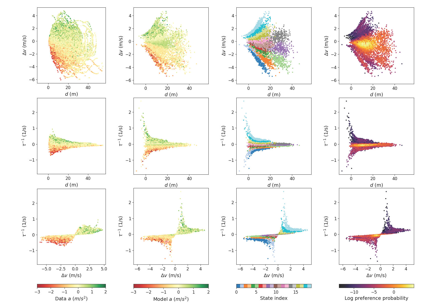
Abstract Driver process models play a central role in the testing, verification, and development of automated and autonomous vehicle technologies. Prior models developed from control theory and physics-based rules are limited in automated vehicle applications due to their restricted behavioral repertoire. Data-driven machine learning models are more capable than rule-based models but are limited by the need for large training datasets and their lack of interpretability. In this project we developed a novel car following modeling approach using active inference, which has comparable behavioral flexibility to data-driven models while maintaining interpretability. We assessed the proposed model, the Active Inference Driving … Enhancing automated vehicle safety through testing with realistic driver models
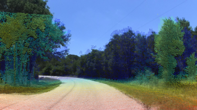
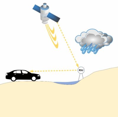
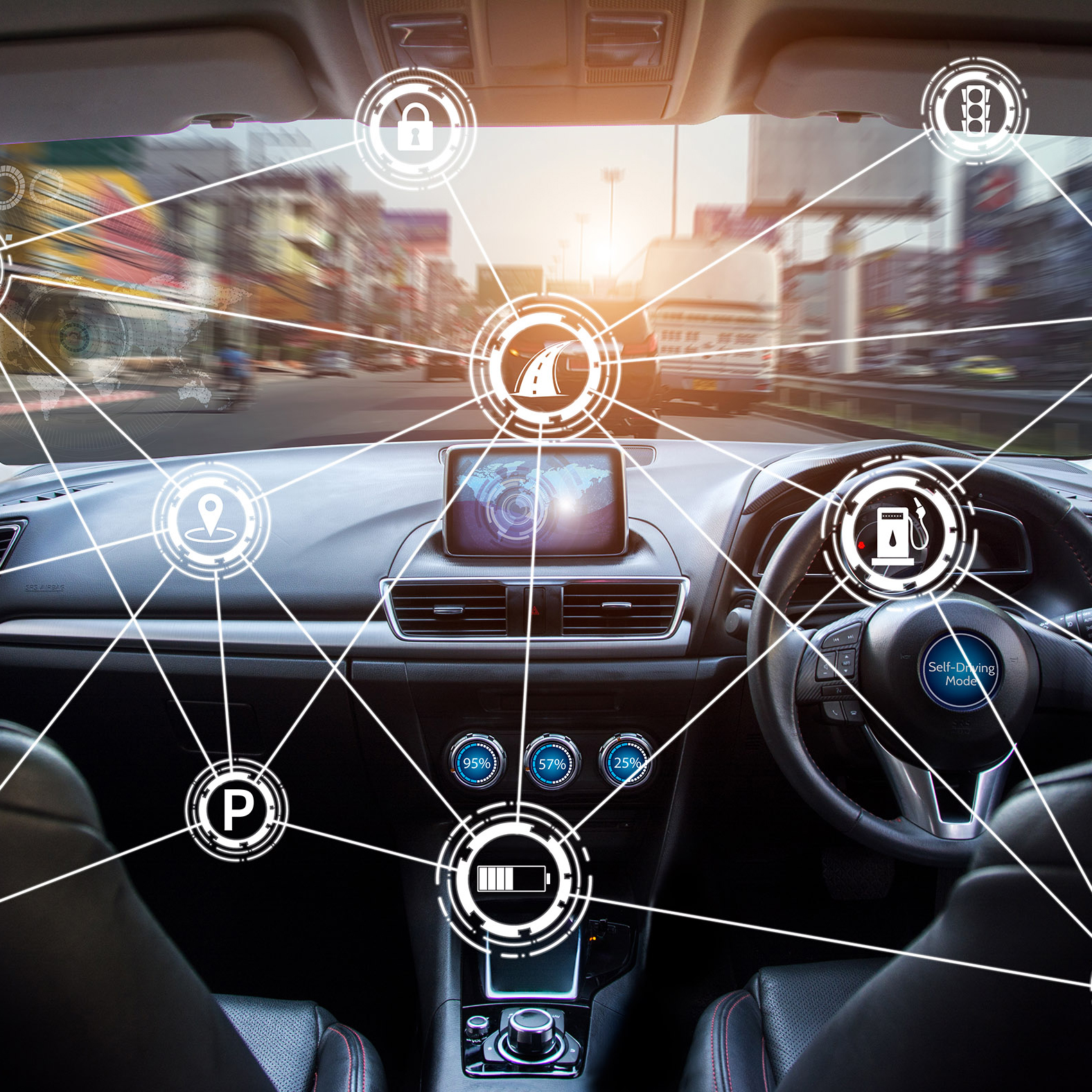
Abstract A significant majority of state-of-the-art autonomous sensing and navigation technologies rely on good lane markings or detailed 3D maps of the environment, making them more suited for urban communities. Conversely, many rural roads in the U.S. do not have lane markings and have irregular boundaries. These challenges are common to many small and rural communities (SRCs), which are sparsely connected and cover huge areas. The objective of this project was to develop an efficient sensing and navigation system for SRCs that uses crowd-sourced topological maps, such as OpenStreetMap, and provides high-level road network information in concert with onboard sensing … Technology to Ensure Equitable Access to Automated Vehicles for Rural Areas
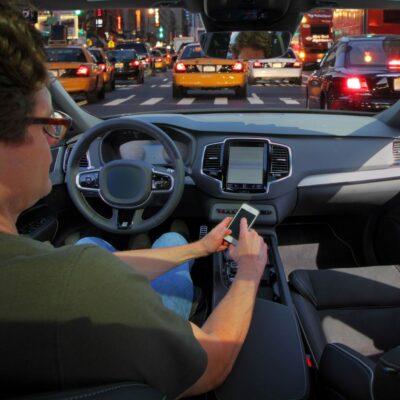
Abstract Automated vehicle technologies vary from simple alerts to partially automated driving tasks that are increasingly available in today’s vehicles. Advanced driver assistance systems (ADAS) seek to alert a driver to critical events (e.g., forward collision warning) or even intervene (e.g., emergency braking, lane-keeping steering) to prevent crashes. These technologies, however, are not available equally across the passenger vehicle fleet, nor is there standardization in how their uses and limitations are marketed to potential buyers or demonstrated at point of sale, including by increasingly popular online “dealerships” like Vroom and Carvana. The proliferation of ADAS has also outpaced current crash … Critical Areas in Advanced Driver Assistance Systems Safety: Point of Sale and Crash Reporting
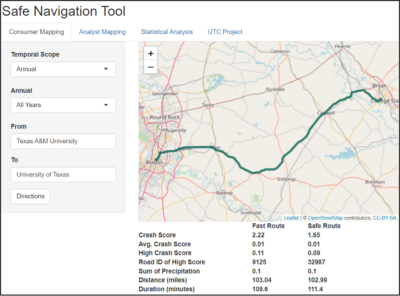
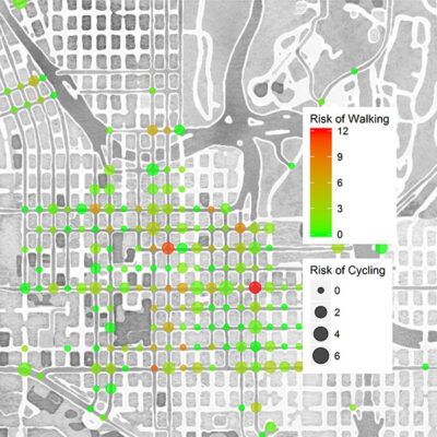
Abstract Popular navigation applications such as Google Maps and Apple Maps provide distance-based or travel time-based alternative routes with no real-time risk scoring. There is a need for a real-time navigation system that can provide the data-driven decision on the safest path or route. By leveraging data from a diverse range of historical and real-time sources, this study successfully developed a user interface for a navigation tool or application that offers informed and data-driven decisions regarding the safest navigation options. The interface considers multiple scoring factors, including safety, distance, travel time, and an overall scoring metric. This study made a … Developing AI-driven Safe Navigation Tool
Abstract Roadway safety in low-income and ethnically diverse U.S. communities has long been a major concern. This research was designed to address this issue by developing a data-driven approach and computational tools to quantify equity issues in roadway safety. This report employed data from Houston, Texas, to explore (1) the relationship between road infrastructure and communities’ socioeconomic and demographic characteristics and its association with traffic safety in low-income, ethnically diverse communities and (2) the type of driver behaviors and characteristics that affect crash risks in underserved communities. The team first built an inclusive road infrastructure inventory database by employing remote … Building Equitable Safe Streets for All: Data-Driven Approach and Computational Tools

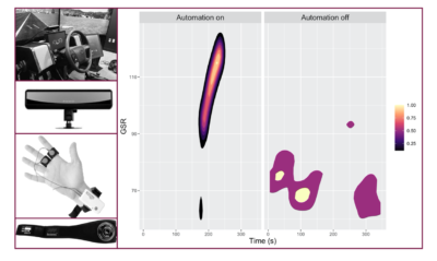
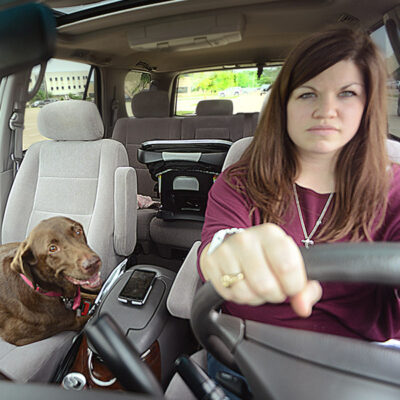
Abstract People operating motor vehicles are often required to engage in decision-making while under substantial cognitive loads imposed by the driving environment. In such situations, distractions, both external and internal, can compromise the safety of individuals and the system. Driving under the influence of elevated emotions has been shown to increase the risk associated with driving by 10 times compared to driving in a calmer emotional state. Aggressive driving behaviors, which include driver interaction with other drivers on the roadway, lane change behavior, and speeding, are often associated with rage and anger, but they are also seen in the experience … Evaluating Emotion Regulation Techniques for Supporting Driving Safety and Performance

Abstract Safety issues that stem from commercial truck parking shortages are a national concern. National hours-of-service (HOS) regulations limit drivers’ time on the road, in an attempt to increase safety by limiting fatigue; thereby, creating a need for drivers to locate safe, secure, and legal parking wherever they are when or before they hit their limits. In addition, the recent rule mandating the use of electronic logging devices (ELD) to electronically record a driver’s Record of Duty Status (RODS), replacing the HOS paper logbooks, further exacerbates drivers’ needs to find adequate parking. If drive time is exhausted where there … Connected Vehicle Information for Improving Safety Related to Unknown or Inadequate Truck Parking
Abstract Advanced driver assistance systems (ADAS) have significantly improved safety on today’s roadways but their impact may be limited by driver errors. Understanding and identifying these driver errors will require the integration of multi-domain datasets through predictive modeling and data integration approaches. The goals of this project are to identify relevant datasets for ADAS error prediction, evaluate modeling approaches for predicting driver errors during ADAS use, and developing models to proactively predict driver errors. Results from the project will be used to guide data collection system design at automakers and develop predictive modeling benchmarks. Project Highlights The project resulted … Identifying Deviations from Normal Driving Behavior
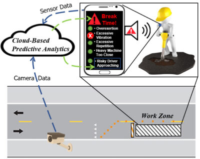
Abstract This project was inspired by a major gap identified in the literature pertaining to work zone safety monitoring systems that leverage advanced technologies for tracking workers, identifying hazardous situations, and alerting workers of danger. Existing systems target safety hazards that are either external to the work zone (e.g., accidents due to vehicular intrusions) or workers’ internal physical/physiological states (e.g., human-factor ergonomics such as improper or prolonged use of vibrating hand tools). This project presents a holistic approach in which visual and wearable sensor data are used for safety monitoring and alert generation to offer a practical mitigation strategy for … A Holistic Work Zone Safety Alert System through Automated Video and Smartphone Sensor Data Analysis
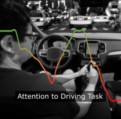
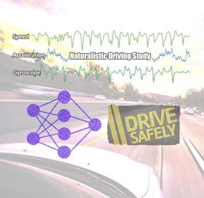
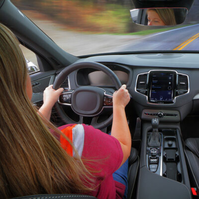
Abstract Distracted drivers are involved in approximately 4 million vehicle accidents each year in the U.S. (Dingus et al. 2016). These crashes result in many lives lost and billions of dollars in damages. This widespread issue has resulted in the adoption of regulations in the European Union that will require all new vehicles produced by mid-2022 to be equipped with driver monitoring systems (DMS; Gibbs, 2019). Although new vehicles would be required to incorporate driver monitoring, the optimal approach for determining/identifying inattention is still up for debate. This project leverages previous research, naturalistic databases, and input from recent literature to develop robust algorithms for assessing when drivers are inattentive to the driving task, while … Improving Methods to Measure Attentiveness through Driver Monitoring
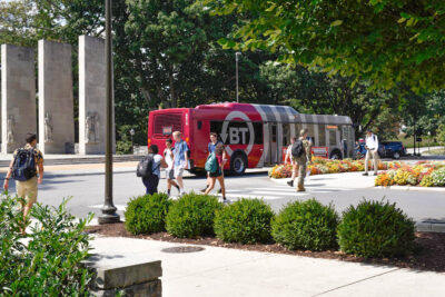
Abstract Encouraging the Virginia Tech (VT) community (including student, faculty, and staff) to walk, use the bus, carpool or ride bicycles for alternative transportation to decrease dependency on vehicle use and traffic around a campus and increase overall safety is a goal of the VT Alternative Transportation Department. This project develops an intervention and education program to encourage alternative transportation to, from, and around campus to reduce traffic on campus. In addition, since there is currently no standardized approach for computing the injury rates for non-vehicle roadway users, this project also refines and assesses a methodology for estimating injury rates … Using Health Behavior Theory and Relative Risk Information to Increase and Inform Use of Alternative Transportation

Abstract The recent emergence of electric scooter (e-scooter) rideshare companies has greatly increased the use of e-scooters around the world, which has increased the number of injuries associated with their use. A primary cause of e-scooter crashes is front-wheel collisions with a vertical surface. This research numerically simulated various e-scooter-stopper crashes across different impact speeds, approach angles, and stopper heights to characterize their influence on rider injury risk during falls. A finite element (FE) model of a standing Hybrid III anthropomorphic test device was used as the rider. The angle of approach was found to have the greatest effect on … Simulation-based approach to investigate the electric scooter rider protection during traffic accidents. A step forward for safer e-scooters and for standardized national safety policies

Abstract Driver impairment, due to drowsiness or fatigue, has a significant impact on the safety of all road users. Assessing an impairment such as driver drowsiness, through the use of vehicle-based technology, continues to be an area of interest. Both the initial detection, as well as continued monitoring, of driver drowsiness have been the emphasis of vehicle-based Driver Monitoring Systems (DMS). Particularly, in-vehicle eye-tracking systems have been implemented, as a way of determining driver state. Specifically, when hands-free driving assistance features are engaged, measures such as the driver’s percentage of eye closure (PERCLOS) are being used to determine driver drowsiness. … Behavioral Indicators of Drowsy Driving: Active Search Mirror Checks
Abstract The goal of the proposed project is to systematically extract traffic safety information from multiple complex sources of flood monitoring such as remote sensing technologies, flow gauges, and weather stations, which can support informed planning for transportation safety against flooding in future smart cities. Flooding poses a significant hazard to the moving vehicles and causes traffic disruption by placing water flow in the transportation network, resulting in sweeping vehicles away, injuries and loss of life of passengers. While different methods to continuously monitor flooding are available in the field of flood management, the collected data is too complex … Evaluation of transportation safety against flooding in disadvantaged communities
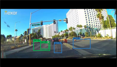
Alternative Title Assessment of Work Zone Pre-Crash Scenarios Using Crowdsourced Data Abstract Pavements play a vital role in the transportation infrastructure in the United States. Damage to public road transportation infrastructure causes roadways to fail to perform as intended and increases crash risks. Road damage must be detected quickly and accurately in order to maintain roads and effectively allocate repair money. In this study, four deep-learning object detection models were used for detecting five types of pavement damages using Nexar Dashcam images. The single-shot multi-box detector (SSD) and faster region-based convolutional neural networks (Faster R-CNN) object detection models using MobileNet … Detecting Pavement Distresses Using Crowdsourced Dashcam Camera Images

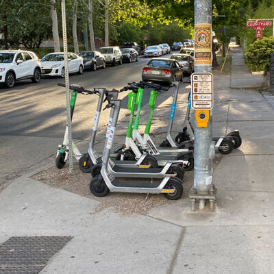
Abstract As rented and shared micromobility options, e-scooters are new and potentially transformative app-based modes that promise to alleviate first mile/last mile mobility issues, congestion, and more. Yet their safe deployment has not yet been systematically understood or standardized by users, cities, or operators. As of December 2019, 1,500 people had been injured and 8 killed in e-scooter crashes. These devices are not yet regulated by a federal agency like the National Highway Transportation Safety Administration (NHTSA) or the Consumer Product Safety Commission (CPSC), and their use is not uniformly regulated at the municipal level. Some jurisdictions are imposing … Micromobility Safety Regulation: Municipal Best Practices Review
Abstract This project supports a student in support of the National Cooperative Highway Research Program (NCHRP) Project 07-23 Access Management in the Vicinity of Interchanges and was led by Karen Dixon (TTI/TAMU)* and Maryam Shirinzadeh Dastgiri (TAMU). This project used a large volume of operational field data, micro-simulation data, and crash data to identify linkages between interchange design, driveway placement, and upstream major intersection location that affect corridor safety. The effort primarily focused on the diamond interchange configuration that is very common in the United States. The methods for determining corridor safety near interchanges can create challenges. Due to … Development of Analytic Method to Determine Weaving Patterns for Safety Analysis near Freeway Interchanges with Access Management Treatments (TTI/TAMU)
This project will contribute to connected vehicles and ADS real-time safety monitoring, NDS data analysis, hail-driving driver safety prediction, as well as fleet and driver safety management programs.

Automated vehicle technologies (AV) have the potential to become one of the most highly disruptive technological applications of our century.
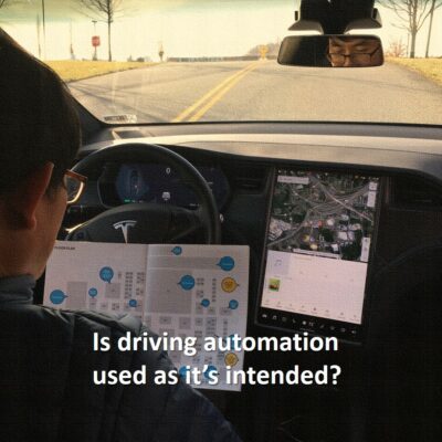
This study will leverage data collected from 50 participants who drove personally owned vehicles equipped with ADSs for 12 months. The work is expected to contribute to a greater understanding of the prevalence and safety consequences of ADS use on public roadways, as well as drivers’ perception of the early production ADS.
Roadway construction and maintenance has become increasingly more common as the transportation system in the United States ages and the population and traffic volume increases.
Today’s connected vehicles have an abundance of electronics and sensors that can passively collect data on driving behaviors, mechanical status, and physical roadway conditions.

This research project will investigate road user interactions with e-scooters.
This case-study project will provide an in-depth examination of e-scooter safety considerations through a data-driven approach using Austin as the proposed study site.
For this Safe-D project, dash video from the NOVA fleet collection effort will be analyzed using machine vision to, combined with additional approaches that offer some redundancy, determine the frequency, timing, and characteristics of L2 feature activations and deactivations.
This project will deploy a fleet of e-scooters on the Virginia Tech campus through an exclusive, controlled research program which will collect data to assess safety impact, what behaviors are exhibited that may be beneficial or problematic, and ways in which kinematic and/or other data may be used to predict risky behavior and develop subsequent countermeasures.
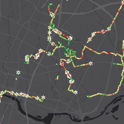
Abstract This project encompasses four different activities to explore safety applications of emerging crowd-sourced data and datasets available from commercial aggregators. The first activity examines systems used to monitor and count pedestrian activity. Developing crash rates for these vulnerable users depends on knowing the volume of activity. Data from metropolitan planning organizations as well as commercial and community-based reports of bicycle and pedestrian activity will be assessed for accuracy by comparing them to manual counts. The second activity will examine waypoint travel pattern data from a commercial data aggregator to determine its applicability to safety analyses. The evaluation will … Exploring Crowdsourced Monitoring Data for Safety
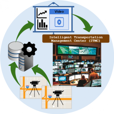
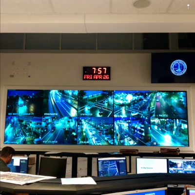
This project will develop an intelligent transportation management center (ITMC) that adopts automated video data analysis to evaluate safety.
This project will analyze large scale continuous naturalistic data as well as event data, both public and proprietary, to study the role of different driving behaviors in the buildup of a safety critical event.
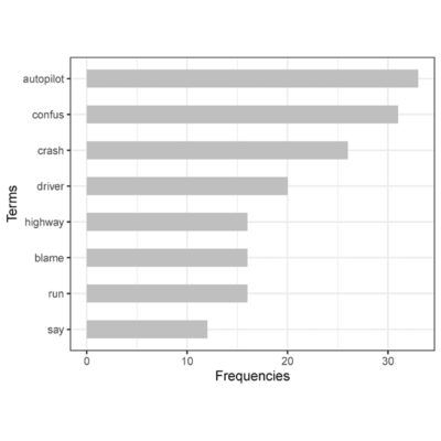
This project seeks to understand the conversation about automated vehicles on Twitter through a network and natural language processing analysis.
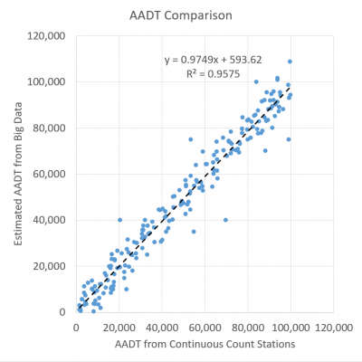
This project seeks to examine whether traffic volume estimates developed from disruptive technologies such as cell phones, GPS/Bluetooth devices, and alternative data sources (e.g., demographic, socioeconomic, land use data) can be used confidently and accurately to support data-driven safety analysis (i.e., network screening) to meet the 2016 Highway Safety Improvement Program (HSIP) Final Rule requirements.
This project seeks to understand the existing systems and how they can be leveraged to provide the City with insight and suggested countermeasures to address the safety issues on these roadways.
This project will the data ownership and privacy implications of big data collection and processing.
This project aims to develop a big data analytics framework and visualization tool to conduct spatiotemporal modeling and classify and visualize aggressive driving behavior using data from emerging technology.
This project will develop a framework which will bring together traditional and emerging data sources, and will be developed in such a way that it can be up- or down-scaled based on the available data sources of a study area. The exposure estimation output will then be used for crash assessment tailored to the needs of the study area.
This project will obtain and analyze detailed data – speed profiles along with selected driver and vehicle variables – from the SHRP2 NDS dataset for portions of trips that occurred on and near freeway ramps.
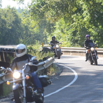
This project will review and analyze existing crash data on motorcycle related accidents, as well as to conduct a detailed literature review on existing motorcycle testing standards and various protocols that foreign Countries have developed throughout the years.
This project seeks to better understand the impact of vehicle occupants in speeding driving behavior.
This project seeks to explore the possibilities of using large sets of naturalistic crash and behavior data collected as part of commercial fleet- and behavior change management programs, collecting tens of thousands of crashes annually.
This project will examine freight and passenger railroad operational and infrastructure needs can be best considered in the development of future AV/CV system architecture.

This project seeks to identify the sources of bias in big data for transportation safety planning and the approaches to mitigating bias in big data for passenger vehicles, transit, bicycling, and pedestrians.
This project will develop a method to evaluate street noise and documented crash rates on roadways.
This educational development project will take previously-devloped in-class activities that show real-world applications, link them to academic concepts and standards, and create curriculum and associated materials that can be used by teachers and other professionals across the nation.
This project will investigate data from multiple sources, including automated pedestrian and bicycle counters, video cameras, crash databases, and GPS/mobile applications (both active and passive monitoring), to inform bicycle and pedestrian safety improvements.

The project will evaluate statistical and other related methods that could simplify the analysis of the unique attributes related to safety and transportation-related big data, and present guidelines that can be used by researchers and practitioners for simplifying data analyses.

This project will investigate the influences on motor vehicle and bicyclist operations within a corridor.